About Geodetics Calculator
The Geodetics Calculator is designed to solve the first ("direct") and second ("inverse") geodetic problems with an accuracy of 1e-6 meters over a range of 27 different reference ellipsoids and spheriods. Background: The...
The Geodetics Calculator is designed to solve the first ("direct") and second ("inverse") geodetic problems with an accuracy of 1e-6 meters over a range of 27 different reference ellipsoids and spheriods.
Background:
The first ("direct") geodetic problem is defined in the following manner: given a point (in terms of latitude and longitude) and a direction ("azimuth") and distance from that point to a second point, determine the location (in terms of latitude and longitude) of the second point.
The second ("inverse") problem is defined in the following manner: given two points (in terms of latitude and longitude), determine the direction ("azimuth") and length of a line (in our case, both a geodesic curve (a great circle) and a rhumb line) that connects them.
Usage:
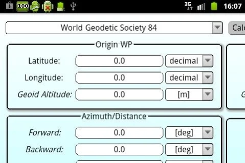
*To solve the first ("direct") geodetic problem, simply enter the origin point, fill direction and azimuth fields and press the Calculate button.
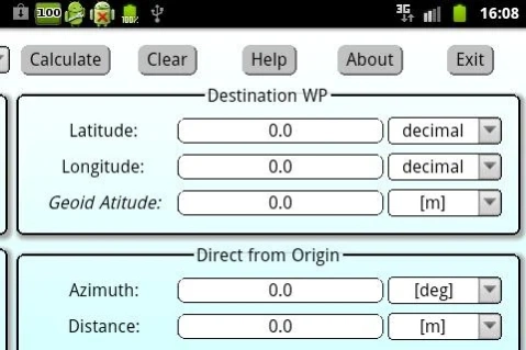
*To solve the second ("inverse") geodetic problem, simply enter the origin and destination points and press the Calculate button.
*In order to change the units in which the input or output fields are given, simply choose a different measurment unit and press the Calculate button.
Terminology:
*Geoid Altitude output field rtepresents the height of the local geoid (EGM96 = Earth Gravity Model 1996) above mean sea level at the origin and destination.
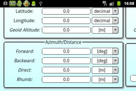
*Forward output field represents the azimuth from origin point to destination point.
*Backward output field represents the azimuth from destination point to origin point.
*Direct output field represents the length of a straight line ("geodesic curve" / "great circle") connecting the origin and destination point, along the reference ellipsoid.
*Rhumb output field represents the length of a rhumb line connecting the origin point to the destination point, along the "meridional earth spheroid model" (radius of 6367.445[km]).
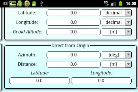
*Latitude and Longitude output fields represent the location of the point located at a given azimuth and distance from the origin point (they are given in degrees with a decimal notation).
Notes:
*Origin and Destination points location can be entered in two different notations:
*Longitude is given in the boundary of [-180.0, 180.0] degrees. Negative longitude represents the western hemisphere and positive longitude represents the eastern hemisphere.
*Latitude is given in the boundary of [-90.0, 90.0] degrees. Negative latitude represents the southern hemisphere and positive latitude represents the northern hemisphere.
*If the origin and destination points are the same, than the distance between them would be zero, and the azimuth between them would be NaN ("not a number").
*If the distance entered by the user is such that the reference ellipsoid would be encircled, than the calculator would take it into consideration.
*Output fields are labeled using indent font, to seperate them from input fiields.
*Geoid altitude is calculated using a bilinear interpolation performed upon a 0.25 degrees grid of point value in a "tide-free" system. The Geoid is given relative ot the WGS84 ellipsoid. Maximum error in Geoid altitude is one meter.
*Rhumb line distance is calculated using earth spheroid radius of 6367435[km]. Deviation from other calculators might originate from the usage of a different earth radius.
Questions or bug reports? please contact me at
[email protected].
For more applications, check out my public profile at http://profiles.google.com/malta.dan/about.
ENJOY
Previous Versions
Here you can find the changelog of Geodetics Calculator since it was posted on our website on 2016-12-29 20:20:57.
The latest version is 1.01 and it was updated on 2024-04-22 14:21:19. See below the changes in each version.
Geodetics Calculator version 1.01
Updated At: 2012-07-30
Changes: version 1.01:,* removed adds.,* application size is much smaller (by almost 50%).,* corrected some typos.
Disclaimer
Official Google Play Link
We do not host Geodetics Calculator on our servers. We did not scan it for viruses, adware, spyware or other type of malware. This app is hosted by Google and passed their terms and conditions to be listed there. We recommend caution when installing it.
The Google Play link for Geodetics Calculator is provided to you by apps112.com without any warranties, representations or guarantees of any kind, so access it at your own risk.
If you have questions regarding this particular app contact the publisher directly. For questions about the functionalities of apps112.com contact us.